Municipal Climate Change Action Plan for the Town of Lunenburg
Location and Flood Zone Description
Lunenburg is a port town located on the South Shore of Nova Scotia, Canada, approximately 70 km southwest of Halifax. It was founded in 1753 and is recognized as a World Heritage Site by UNESCO (UNESCO, 1995).
Lunenburg is primarily impacted by coastal flooding. Sea level rise and storm surge extents for years 2025 and 2100 are shown in Figure 6-2. According to different stakeholders, the affected zone in Lunenburg is flooded between “once every two years” to “three to four times a year”. This area includes important community facilities (CBCL, 2015), such as:
-
the “Blue Building”, which is used as storage space for public works;
-
the Community Centre, which also acts as an emergency shelter;
-
the Ambulance Base; and,
-
the Bluenose Academy.
Flood-affected community facilities in Lunenburg are shown in Figure 6-3.
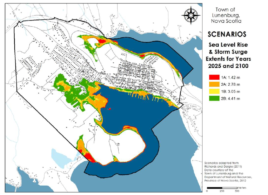
Figure 6-2: Sea Level and Storm Surge Extents for Scenario 1 (2025) and Scenario 2 (2100), Cases A (Extreme Sea Level Rise) and B (Extreme Sea Level Rise + Storm Surge) (CBCL, 2015)
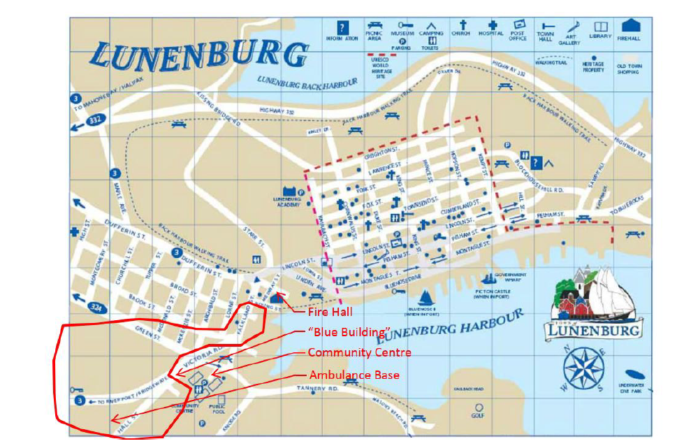
Figure 6-3: Lunenburg Town Map, With Important Buildings Affected by Flood Highlighted (CBCL, 2015)
Flood Zone Adaptation Approach
The Town of Lunenburg’s Municipal Climate Change Action Plan identifies several options for climate change adaptation (which includes flood adaptation and flood mitigation). General climate change adaptation options identified included protect, accommodate, retreat, planning, and public education (summarized in Table 6-1).
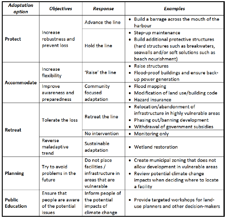
Table 6-1: General Climate Change Adaptation Options with a Focus on Sea Level Rise (CBCL, 2015)
From these general adaption options, several actions were recommended to address current and future flood risk, including:
-
Design and Implement a Flood Management Program in the Victoria Rd. / Hall St. Area;
-
Continue with Planning for Flood Management in the Vicinity of Victoria Road and Falkland Street;
-
Ensure Critical Infrastructure Has Back-Up Power;
-
Account for Sea Level Rise in Shoreline Infrastructure Design and Maintenance;
-
Continue Storm Sewer Separation from Sanitary Sewer;
-
Begin Preparations to Relocate Important Facilities;
-
Additional Emergency Preparedness Considerations;
-
Establishment of Coastal and Floodplain Setbacks;
-
Organizing a Process to Collect Municipal Staff Knowledge about Locations of Climate Change Impacts;
-
Implement Monitoring at Dares Lake;
-
Review of Municipal Structures for Snow and Ice Loading;
-
Annual Regional Meeting;
-
General Climate Change Reviews and Stormwater Management Plans; and
-
Education.
Outcome
The Town of Lunenburg released a Municipal Planning Strategy in 2021 (Town of Lunenburg, 2021), which makes reference to the Municipal Climate Change Action Plan.
Financial support for this project was provided in part by Natural Resources Canada through the Flood Hazard Identification and Mapping Program (FHIMP). We also gratefully acknowledge the funding and support provided by the Government of Nova Scotia through the Municipal Flood Line Mapping Program (MFLMP).

