District of Muskoka Flood Modifications Review
Location and Flood Zone Description
The District Municipality of Muskoka is located in Central Ontario, Canada. Flood hazards in this watershed include pluvial, riverine, and lake flooding.
Flood Zone Mitigation Approach
The Muskoka River Watershed experienced several major flooding events (specifically in 2008, 2013, 2016 and 2019) that caused significant damage to municipal infrastructure and private property. This prompted the District Municipality of Muskoka to scope and review 12 projects designed to describe the existing conditions within the Muskoka River Watershed, and to inform a future integrated watershed management approach to flood risk reduction.
For this project, Hatch identified 10 structural mitigation options amongst five priority areas in the Muskoka River Watershed. As an example, one of those options is the installation of a berm to prevent flooding of commercial waterfront property in the Town of Huntsville. The proposed flood protection berm would serve to reduce flood inundation severity. The concept includes an earthfill berm along most of the shoreline and a removable/mobile flood protection wall for a section of the shoreline that would continue to allow unobstructed view of the river during non-flood conditions. The horizontal alignment of the proposed berm is presented in Figure 7-6.
Outcome
The implementation of these 10 flood mitigation measures is a work in progress. Future work will be completed to evaluate operational and structural changes that may be required to mitigate potential increases to mid-winter flooding risk (Hatch, 2022).
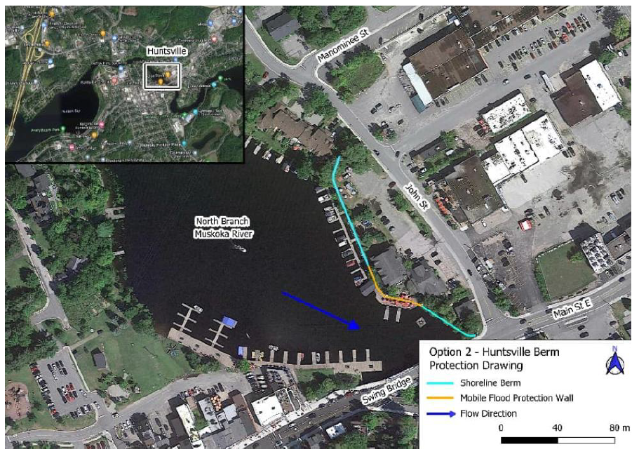
Figure 7-6: Approximate Alignment of the Berm Protection in Huntsville, Ontario (Hatch, 2022)
Financial support for this project was provided in part by Natural Resources Canada through the Flood Hazard Identification and Mapping Program (FHIMP). We also gratefully acknowledge the funding and support provided by the Government of Nova Scotia through the Municipal Flood Line Mapping Program (MFLMP).

