Mahone Bay Living Shoreline
Location and Flood Zone Description
The Town of Mahone Bay is located on the South Shore of Nova Scotia in Lunenburg County. Flood hazards in this region include riverine and coastal flooding.
Flood Zone Mitigation Approach
Mahone Bay is highly vulnerable to the effects of climate change, include sea level rise and storm surge. A study completed by CBCL included developing flood maps showing coastal flood levels in Mahone Bay Figure 7-7.
Using this information, CBCL conducted a flood prevention and shoreline enhancement plan involving the development of aesthetic flood mitigation solutions to address coastal and inland flooding (CBCL, 2016b).
Solutions identified included “living shorelines”, which are a set of erosion control measures that include a suite of techniques to minimize coastal erosion and maintain coastal process. These techniques are applied to protect, restore, enhance or create natural shoreline habitat.
In the case of Mahone Bay, the living shorelines (Figure 7-8) included the following components (Coastal Action, 2025):
-
Rock Sills: A hard engineering structure that runs parallel to the shoreline. Rock sills help reduce wave energy and storm surge impact;
-
Tidal Wetland: Fills the area between the rock sill and the shoreline with planted native species. Tidal wetlands naturally filter stormwater runoff and reduce storm surge and wave energy. They additionally create valuable coastal habitat for fish and bird species;
-
Vegetated Bank: Graded areas planted with native shrubs and herbaceous perennials. Vegetated banks help to stabilize the soil.
Outcome
Coastal Action continues to give updates in their webpage regarding the Mahone Bay Living Shoreline project, such as a 100 metres long expansion along the shoreline.
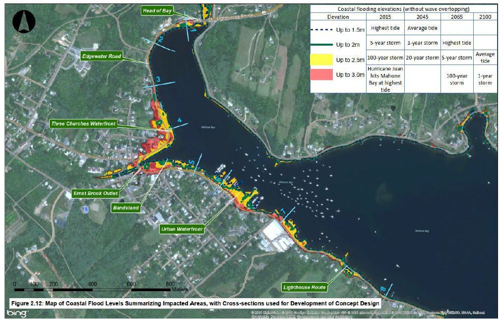
Figure 7-7: Map of Coastal Flood Levels in the Town of Mahone Bay (CBCL, 2016b)
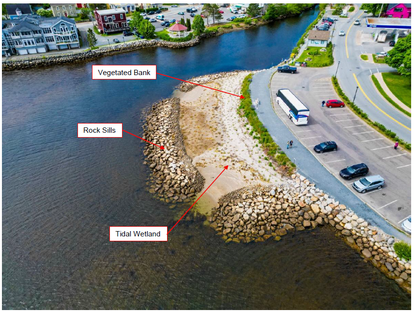
Figure 7-8: Living Shoreline in Mahone Bay (Coastal Action, 2025)
Financial support for this project was provided in part by Natural Resources Canada through the Flood Hazard Identification and Mapping Program (FHIMP). We also gratefully acknowledge the funding and support provided by the Government of Nova Scotia through the Municipal Flood Line Mapping Program (MFLMP).

